Last week marked Esri’s annual User Conference in San Diego, and what a conference it was! It’s always fun to see geospatial friends and meet new ones. Part of my time at this year’s gathering was spent presenting alongside Kenneth Field and John Nelson for our talk entitled “Designing Thematic Maps.” This year, Ken had the idea of re-creating three classic maps: John Snow’s cholera map (1854); Charles Joseph Minard’s Napoleon Russia Campaign 1812-1813 (1869), and Cheysson’s per-capita-traffic map (1882). In the many weeks leading up to the conference, each of us tinkered away at our own re-creation attempts, and we’d then reveal our new takes to each other and the audience live during the presentation. I’m pleased to say that it was a blast.

Co-presenter gratitude
Perhaps part of the reason I enjoyed giving this particular session was that for two-thirds of the time I myself was an audience member; I had either not seen my co-presenters’ maps or not heard about their techniques. (I had seen some of Ken’s maps but had not heard him describe the methods he used). So, before I share my version of one of these classic maps, I want to share some thoughts on my colleagues’ effective approaches. I have many more accolades for each of their approaches than what I say below, and if you were able to attend, you know why.
Ken creatively wedged the concepts of 100+-year-old maps into modern GIS (ArcGIS Pro) and meticulously produced complete replicas and stunning interactive 3D versions. It was a pleasure hearing his skillful approach, and he’s an entertaining presenter on top of it all.
Two of the three maps we redesigned had a somber subject matter: disease outbreak and the tragedy of war. John approached both with the respectful tone the subjects deserved, including incorporating a part of himself into one of the maps. It was very impactful. And of course the visual results were clarifying as well. His small-multiples approach for the Cheysson map was beautiful.
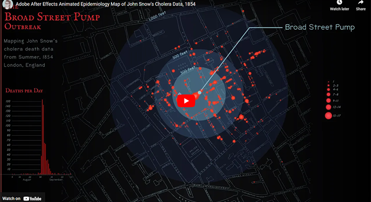
My animated re-creation of John Snow’s 1854 Cholera Map
The famous Broad Street Pump cholera map credited to John Snow is taught to many GIS, cartography, and even epidemiology students, as an early application of GIS for disease mapping. With our modern-day understanding of water borne disease, the connection between the Broad Street pump and the cholera epidemic that surrounded it is clear.
This brings me to a thought — perhaps a good reminder for mapmakers — or at least myself. And it is something that I think about more now than I did when I was first learning about GIS — hindsight bias. In the case of the John Snow map, hindsight bias is the tendency to think, “Clearly, more cholera deaths occurred near tainted water pumps, so it makes sense that this map verifies this obvious connection.” With the advantages of historical hindsight, in today’s world, this connection makes sense. Mapmakers now have access to incredibly powerful tools, and with 160+ years of modern scientific advancements, we have the benefit of loads of empirical evidence for water borne illness and germ theory.
But, in terms of the spread of cholera, Europe in the mid-1800s did not have the advantages that we do today. It makes understanding Snow’s and others’ efforts as truly ground breaking. In mid-1800s London, cholera outbreaks starting emerging throughout London. As these outbreaks increased, doctors were still trying to identify the cause, while Londoners were losing neighbors and family members with each outbreak. It’s a real horror that I never fully considered until re-creating this map. I deep dove into reading about this period in London, and for those interested, I recommend doing the same. It could be because quite recently, we experienced our own community emergency responses to COVID-19 outbreaks that I felt much more connected to the importance of this story.
About the map
I created this map by starting in ArcGIS Pro (GIS), and then exported it as an AIX file. I opened the AIX file in Adobe Illustrator, made possible with the ArcGIS Maps for Adobe plug-in. Then I styled the map in Illustrator to fit my desired aesthetic, and imported the results in to Adobe After Effects for animation.
- In the lower-left, the dates for the span of the outbreak play with the sound of a clock ticking for each day
- Above the date is a bar chart that is slowly revealed as time moves on, and cases increase
- The map shows the location for each case, and they each appear on the date they occurred
- The points on the map have a faint radiating ring that fades away as the points appear
- As the cases begin to spike around September 1st, so I increased the audio for this period of time.
- The music is licensed under the pixabay Content license. I am appreciative for them sharing their music that aligned very well with this animated map.
- At the end of the map, the points morph into graduated symbols showing the intensity of the cholera cases for this particular outbreak.
- Finally, the map shows a 3-ringed geographic buffer of 300, 500, and 1000 feet around the Broad Street Pump.
I hope to share a map-animation tutorial soon. You can view my takes on the Minard and Cheysson maps in the portfolio section.


